In the aftermath of the damage occurring to the East Coast and Hawke's Bay, I tried to do a bit of a dig around to what other examples there were (world-wide) of forestry having such an adverse impact upon both the environment and society.
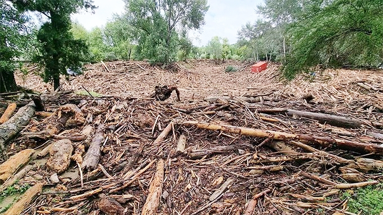
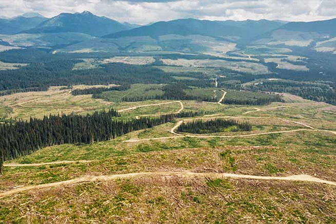
Not surprisingly Canada, or in particular British Columbia, as recent as 2021 has highlighted significant instances where slash and clear felling has significantly contributed to increased flooding and the associated damage to roading and also to the down stream societies. They have had the added contribution of forest fires which added to the denuding of the land.
Fortunately, New Zealand forests have not yet had to deal with major forest fires although the stats must be moving in the direction of an increased likely hood of this occurring.
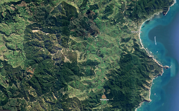
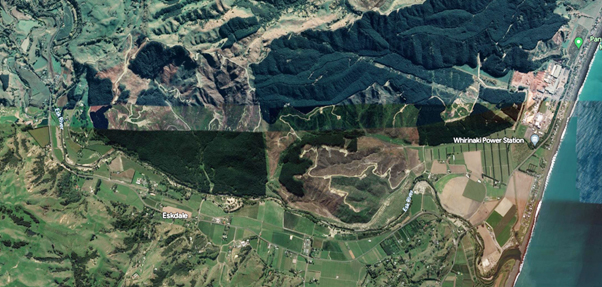
The scale of clear felling in the New Zealand areas affected worse by slash induced floods can be seen in the Google Maps snap shots below. I could have taken others which include the Te Karaka catchment of Whatatutu also heavily flooded and inundated by logs or parts of Wairoa.

Google Maps shot of inland Tokomaru Bay and Tolaga Bay north of Gisborne

Google maps shot of the Esk Valley where major flooding occurred.
The Canadian example unfortunately gave little in the way of positive news for remediation etc. In fact some of the commentary was about how much in the way of taxpayers money had been used to subsidise the forestry industry and there still appears, at least in British Columbia, to be no cohesive policies to prevent both over-logging and the resulting slash and its associated issues.

Source: Mongabay news.Ca
I could have also included many equally descriptive photos of farmland (in New Zealand) without trees on where there has been extensive erosion and questions also need to be asked how is the lack of protection for soils still being allowed to happen? Parallels could be drawn between hill country erosion and now forestry mismanagement and the issues dairy has had to face up to regarding water quality. None of these issues were or are going to be quick fixes but lines in the sand need to be drawn.
Forestry did have guidelines at least as far back as 1992 with the first Code of Practice for Forestry Operations. It has been updated since, and includes under environmental legislation clauses from the RMA, such as:
(b) Where it is likely that an activity will result in any significant adverse effect on the environment, a description of any possible alternative locations or methods for undertaking the activity. (Must be included in applications) It does include guidelines on how slash should be managed.
To manage slash and wood debris to avoid adverse environmental effects, especially surrounding landings e.g. ‘birds nests’ and material deposited in waterways.
Rules General rules
(Compulsory) • Comply with applicable Council requirements, Resource Consent conditions, Historic Places Trust Authority and any other legal requirements.
• Ensure slash management requirements have been identified and clearly mapped or documented before the operations starts e.g. slash storage sites.
• If there is insufficient space for onsite slash disposal, plan for temporary slash storage that will allow slash to be accumulated and then taken off site, e.g. transported to another landing site.
There is even included what the consequences of breaching such clauses are: that is, $200,000 fines or two years in prison. Given councils are the authority meant to be overseeing these activities, serious questions need to be asked of them.
None of this however is going to rectify what has happened or what else may happen in the coming years. Like the water issues with dairying, it may be decades before natural processes run their course even if root causes were fixed tomorrow.
Should there be a moratorium put on harvesting of forests that cannot show that they will not contribute to a slash problem?
Given the current price of carbon (currently dropping to $65 per tonne), if the forestry companies were required to no longer log these blocks and instead convert them to carbon farming enterprises what would be the cost to them?
The thought of providing forestry companies compensation (as was mooted by the forest industry) would go down like a lead balloon especially by those downstream from them who have been so seriously affected by the flooding and damage. Given that Government is committed to get to a zero emissions status for the country by 2050 and looking as though it would have to purchase off shore offsets (forestry) to balance the equations these problematic forests could help solve part of the problem. If they are allowed to continue a “Business as Usual “policy it will only make living down stream of them more dangerous and expensive.
Perhaps if forestry were asked/required to pay for the costs of all their externalities they might welcome the chance to put away the chainsaw. In the short-term jobs in forestry may disappear but already there are vineyard and horticultural block owners who are talking about not replanting. So, whose jobs are more valuable?
The other alternative will be to totally review their practices and utilise more selective (less clear felling) this may also have the companies end up at the same place as being shut down as economics may limit their viability.
One thing is for certain, something is going to have to change. Forests were put there for the correct reasons (arguably the wrong trees but we’re stuck with them now) but there have been some serious short comings in what has happened and been allowed to happen since.
Log Prices
Select chart tabs
18 Comments
What it will look like? Just like pre Gabrielle. If you have forests in your landscape you are going to have forest debris.
questions also need to be asked how is the lack of protection for soils still being allowed to happen?
Nail on the head. Right across the rural sector this is an issue.
Without these soils we are doomed, yet the sector is blind to it. How many decades before our lands are exhausted and are primary sector is rooted?
The "root" problem was deforestation in the early 20th Century for pastoral farming on some of the most erodable soils on the planet. The exotic forest subsequently planted has prevented soil loss and even more silt from coming down in rainfall events. Gabrielle was so extreme that standing forest came down as well. A lot of the beach "slash" includes standing trees, poplar slope stabilistion and riparian planting.
In retrospect, things could have been done better. There should have been catchment limits on how much forest can be in cutover at one time. Slash could have been burnt or removed (at considerable cost to the forest owner). Debris traps could possibly be constructed at the head of flood plains, but this would require the purchase of someone else's land.
I'm not sure there are any easy answers though. These hills need to be in mature forest of some description. Carbon forestry would provide a income stream for eligible post-89 forest land, but most of the existing forest is pre-1990. The community benefit of continuous cover forestry is soil conservation, more regular water flow, and higher water quality but there is currently no mechanism for rewarding this.
+1 for burning it.
Yes, burn it. But as biofuel, to replace coal and other fossil fuel use:
https://www.bioenergy.org.nz/news/banz-says-forestry-slash-could-help-d…
https://www.bioenergy.org.nz/announcement/genesis%E2%80%99-biomass-tria…
https://www.bioenergy.org.nz/event/web230302-huntley-power-station-tran…
James Shaw will come down on you like a ton of bricks.
Jeanette Fitzsimons proposed burning slash to replace coal 10 or so years ago.
from the Green party forestry policy.
- "Forestry and energy policy should align to promote clean burning biomass and biofuel opportunities, especially to replace coal use."
Written 10th May 2020 by the way , not a kneejerk reaction to the current scenario.
Several years ago a friends farm was badly damaged by the neighbours huge pile of slash on the edge of a steep face slipping into the stream and being swept away during a storm. Downstream the fences, paddocks and bridges wiped out costing half a million to repair. The foreign forest owner decided it was too expensive to admit liability for. The council did nothing, the local MP (now a cabinet minister) did nothing. It looks like the victims of this disaster will get nothing from those culpable.
The article this is taken from, was published in 2016. The Cyclone Gabrielle effect on Eskdale seems almost deja vu-like to the event in 1938.
Overrunning has been a key player in most of the heavy rainfall events that have affected the provinces of Hawke’s Bay and Gisborne, such as Cyclone Bola and also the Esk Valley flood of April 1938. This latter event lasted three days, bringing up to a metre of rain to an area of Hawke’s Bay about 16 kilometres wide and 60 kilometres long from Kotemaori to the watershed of the Tutaekuri River. Parts of Napier, Clive and Hastings were flooded a metre deep and the level of Lake Tutira, north of Napier, rose by three metres after more than 300 millimetres of rain in 14 hours. Worst hit was the Esk Valley, where the river rose 10 metres in one stretch.
Fifty-four bridges were washed away or severely damaged across the district, stranding many people. Slips were widespread. One farmhouse, well above the Esk River, was partially destroyed by one and the occupants forced to flee through the rain to the woolshed. Minutes later, a larger slip crushed the rest of the house and buried the remains under 15 metres of debris. The family were forced to stay in the woolshed for three days before the river fell enough for them to escape on horseback.
So much sediment washed into the river that the Esk Valley was left covered in silt one to three metres deep when the floodwaters subsided. The water was more than two metres over the floor of the Eskdale Railway Station, and silt lay 1.6 metres deep. The silt was dug out of some houses but the old road running up the valley remains buried beneath the road since built over it. Once the silt had consolidated on farmland, new fences were installed; some posts were placed on top of the old buried posts.
Some families were cut off for weeks and supplies had to be dropped to them by aircraft. One aeroplane crashed in the Pakuratahi Valley and the injured crew had to wait 19 hours before medical help could reach them as the bridge over the Esk River was down. A wire was taken across the flooded river by a man on horseback with some difficulty as the horse lost its footing several times. Once the wire was secured, a boat was attached to it, enabling the crossing to be made.
The extent of the erosion was mostly blamed on the intensity of the rain, which reached 420 millimetres in 24 hours at Puketitiri on April 24, but the killer Hawke’s Bay earthquake of 1931 may also have contributed to instability of the land. There had also been record rain in late January, when the remains of a tropical cyclone affected Hawke’s Bay, triggering some slips. Widespread thunderstorms in the middle of February added more rain to the landscape. One of these caused a flash flood in the Kopuawhara Valley that drowned 21 people working on the tunnels for the railway between Napier and Gisborne.
Much of Hawke’s Bay had recovered by the following summer, but not the Esk Valley, which remained a desolate wasteland of dried mud and dead trees, prone to dust storms as soon as the wind got up.
As well as being a year of heavy rain, 1938 also had record high temperatures in numerous places, some of which were broken only last summer. One of the reasons for this was that the sea around New Zealand in 1938 was about 1ºC warmer than average. This helped warm the air as well as increase rainfall by evaporating more water into the atmosphere.
Currently, the ocean surrounding the country is again warmer than average, so we face an increased risk of heavy rain in the coming months. Last summer, a strong El Niño affected the Pacific Basin. While a strong La Niña often follows close on the heels of a strong El Niño, this has not happened yet, so the coming summer may well be a neutral year, stuck halfway between the two.
Historically, these neutral years have seen some of New Zealand’s worst encounters with the re-intensifying remains of ex-tropical cyclones, such as Cyclone Bola in 1988, the Wahine storm of 1968, and the storm of February 1936—arguably New Zealand’s worst of the past hundred years.
https://www.nzgeo.com/stories/inundated/?fbclid=IwAR0ifQH8H6m5KNVHnLghz…
A coincidence that a paper was published in 1938 on made made climate change. https://www.theguardian.com/environment/blog/2013/apr/22/guy-callendar-… NZ didn't pay too much attention and probably no different from the rest of the world at the time so whether you are climate change alarmist or skeptic about man made CC, it's happened before in the area. The main difference being population and the extent of forestry so it was forseeable. After all only 85 years ago.
Climate change first appears to have been raised in 1824.
In 1824, Joseph Fourier calculated that an Earth-sized planet, at our distance from the Sun, ought to be much colder. He suggested something in the atmosphere must be acting like an insulating blanket. In 1856, Eunice Foote discovered that blanket, showing that carbon dioxide and water vapor in Earth's atmosphere trap escaping infrared (heat) radiation.
https://climate.nasa.gov/evidence/#:~:text=In%201896%2C%20a%20seminal%2….
Yes, historically climate change had been written about, though perhaps not long being out of a financial depression, and war potentially looming, had folks concentrating on other things, in 1938. Thankfully, now we have technology that can help us make more informed decisions about land use. There has been work done on this at catchment level in some areas, and the whole of Southland has been physiographically mapped. Some catchment groups are using this information to inform decision making. However as has been mentioned by others you can plan/mitigate heavy rain, but the amount of rain that fell in a relatively short time would have undone a lot of work - just ask the farmers who had spent years planting natives in gully's and riparian strips, who have seen the lot now gone.
We need to review all landuse on these steep erodible soils. As noted you could include photos of large areas of farmland gone - some of the advice given to fix is chilling, throw on some grass seed and alls good. There is a place for farming and forestry here but a lot of land needs to retired to some form of tree cover and left. There’s going to be some hard calls on land abandonment let alone that many roads cannot be rebuilt or we can afford it.
People need to realise at certain rainfall intensity and volume everything comes down. Look at Auckland and Coromandel.
Go to any Westland beach after a big storm and it’s littered with trees and debris. Just as they would have been here before we cleared all the bush.
No matter what you do, farming or forestry, there is always risk. Without some of both the EC is doomed to becoming a welfare state.
What is the land worth that is left? Farmers are pretty safe on the EC that forestry buyers are gone - it’s trading amongst farmers now so good luck on that - could be some major land price corrections coming. Will banks finance this country? Will insurers cover it? Would you buy a property with slips everywhere and a high/guaranteed chance it will happen again? On that will FMG survive being a mutual company - plenty of rumours in the market.
For farmers the best chance they have is permanent carbon with exotic or native but they don’t want that and looking at photos there’s almost been zero moves to do this.
The first thing that needs to be done is to get out the physiographic, basic underlying geology maps (or get it done if it already hasn't been done), and maybe even do some radiometric mapping - if it already hasn't been done, and then, and only then, sit down to discuss what land use, where. Only then can we make informed decisions about what the options truly are. While it can be expensive to do if it already hasn't been, it will be cheaper for the govt to get it done, than have to contend with the same thing happening within another 100 years.
What a disaster, and this government says we should be doing more forestry and less farming. They reckon you get the government you deserve.
Forestry owners save hundreds of millions of dollars every year, by storms flushing their waste/slash down streams and rivers. Once these storms clear their waste covered hillsides, re-planting is far more effective and far less expensive. MBIE is required by law to audit Councils to make sure this kind of thing does not happen. Based on the fact that it keeps happening, it seems MBIE allegedly is negligent and purportedly should full compensation to property owners. In my opinion MBIE is allowing the forest owners to use out streams and rivers as their toilets.
Replanting occurs straight after harvest. Ideally, some slash should be retained, because the residue carbon and nutrients end up back in the soil. Productivity is reduced if this doesn't happen. But, the East Coast geology and climate makes that strategy risky.
Your comment ostensibly proves the Forestry industry knows "that strategy is risky", so if they knew/know then that purportedly makes the Forestry Industry criminally negligent and $liable.
NEWS FLASH - There is no excuse for NOT appropriately containing all forestry waste within commercial, privately owned pine forested land.
FACT CHECK - it allegedly is waste as it (be it pine slash or any other pine material) has been produced or is a by -product or an adverse effect of production.
I feel the elephant in the room is, why haven't the NZ Police charged the forestry owners and Minister Stuart Nash with wilful damage and possibly criminal man-slaughter by now?

We welcome your comments below. If you are not already registered, please register to comment
Remember we welcome robust, respectful and insightful debate. We don't welcome abusive or defamatory comments and will de-register those repeatedly making such comments. Our current comment policy is here.