
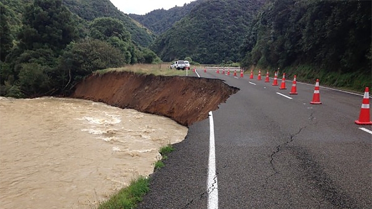
Statistics New Zealand has released its latest statistics on highly erodible land and long-term soil erosion, finding that even though the North Island comprises only 43% of NZ’s total land area, 60% of the country’s highly erodible land was located there in 2022.
Using modeled data from Manaaki Whenua Landcare Research, Stats NZ updated its estimated long-term soil erosion and highly erodible land indicators to the end of 2022 on Wednesday.
Stats NZ says the long-term soil erosion indicator assesses long-term soil erosion levels throughout New Zealand by using the New Zealand Empirical Erosion Model (NZEEM) and relies on two different datasets.
These are the ‘Woody layer’, which has seven versions from Sentinel-2 satellite images between 2016 and 2022, and the New Zealand Land Cover Database (LCDB), which has five versions from SPOT and Landsat 7 ETM+ satellite images for 1996, 2001, 2008, 2012, and 2018.
“The ‘Woody layer’ is used for producing the estimated long-term soil erosion map for New Zealand in 2022 and hot spot analysis from 2016 to 2022; LCDB is used for generating average soil erosion rate data for each region in 1996, 2001, 2008, 2012 and 2018, providing five ‘snapshots’ over a 22-year period,” Stats NZ says.
Both sources track land cover data which shows what’s covering the land like vegetation and buildings.
Based on the Woody layer dataset, Stats NZ says an estimated 182 million tonnes of eroded soil entered New Zealand’s rivers during 2022.
Of that number, the West Coast had the largest amount of sediment washed away in 2022 – 48 million tonnes – while Gisborne had the second highest amount of eroded soil washed into waterways – 36 million tonnes.
Stats NZ also presented findings on “statistically significant clusters” of areas around the country that had heightened and reduced erosion rates compared to the national average from 2016 to 2022.
They were described as “hot and cold spots” depending on if the area had high (hot) or low (cold) soil erosion rates.
It did this using data from the New Zealand Empirical Erosion Model (NZEEM) specifically derived from the ‘Woody layer’ dataset.
Between 2016 and 2022, the central North Island and the Nelson and Marlborough regions had low rates of soil erosion relative to national average and were identified as cold spots.
Hot spots in the same period were found in the west coast of the South Island, the east coast of the North Island, Taranaki, Waikato, and Northland which had high rates of soil erosion relative to the national average.
Stats NZ’s environment and agricultural statistics senior manager Stuart Jones said New Zealand experienced “high levels” of soil erosion due to steep terrain, high rainfall, and earthquakes.
Highly erodible land
The Government department also released how much land was classified as highly erodible in 2022 using the same datasets that were used to measure long-term soil erosion.
“Hot spots were identified in many areas across New Zealand representing areas with significantly higher proportions of highly erodible land at risk of erosion compared to New Zealand on average,” the agency said.
Using the Woody layer dataset, Stats NZ found Gisborne had the highest proportion of its land classified as highly erodible land in 2022 – 15% or 1,280 km² – of all regions across the country.
Risk of erosion by landslide was found to be the most common class of erosion risk, representing 75% or 9,575 km² of areas at risk of erosion which is a 4% of NZ’s total land area.
“60% of the area at risk was in the North Island, despite the North Island comprising only 43% of the total land area of New Zealand,” Stats NZ said.
Because the newly released data is only to 2022, it paints a picture of what land erosion looked like around the country before the flooding and cyclone disasters that NZ experienced in 2023.
Cyclone Gabrielle caused significant devastation to the Gisborne district, damaging much of its land, infrastructure and water supply.
Following the cyclone, the Gisborne District Council said 100km of 285km of water pipe network was damaged during Cyclone Gabrielle.
In a rapid assessment of land damage published by the Ministry for the Environment last July, the Ministry said the total number of landslides – each typically comprising a thousand tonnes of soil – was over 300,000.
At the time, the Ministry estimated the total mass of landslides to be at 300 million tonnes and an economic cost of approximately $1.5 billion which it says was conservatively estimated at $5 per tonne of eroded soil.
1 Comments
Interesting but no great revelation or new knowledge/understanding in those stats. Just putting numbers on a natural process. None of those stats come as a surprise to me. Just look at the proliferation of geologically young, soft sedimentary rock types, particularly along the NI east coast couple with being highly seismically active.
Coupled with that (and a bit tongue in cheek) - all the mountains aspire to be flat land eventually.
Cyclones Hale and Gabrielle demonstrated that even 20 year plus afforested slopes fell off the sides of hills.
60 years ago, native species dominated the drift wood/slash deposits on beaches, now it's dominated by exotic species. I'm no excusing dodgy handling of harvest slash though. Just recognising that species mix has changed over time, even in catchments where little commercial harvest is undertaken.
Erosion is a natural process, accelerated a little by land use, but not caused by land use. In my part of the world there are many land slides where the shear face is 10m to 30m below the surface - no trees have rooting systems deep enough to anchor the to the underlying "rock". It can be argued that the additional weight of trees can increase the slip risk. Particularly in the climatic scenario of the 15 months preceding last year's multiple cyclone events. February 2022 was a very wet month on the east coast - far from the usual summer dry climate that is typical for the NI East Coast. Soils became wet - at or exceeding field capacity for the next pretty much 20 months. Meaning soils were already carrying pretty much as much water as potentially possible. Talk with farmers about the challenges of getting around on quads and side by sides over that period. It was problematic. Horses came back into use as a result.
My conclusion is that there is nothing humans can do to halt erosion, not even shutting it up and walking away. Yes there are strategies that can be applied that successfully slow the erosion processes in "normal" seasons. But when it comes to the situation faced through 2022 and 2023, even the best efforts have been no match against mother nature.
We welcome your comments below. If you are not already registered, please register to comment
Remember we welcome robust, respectful and insightful debate. We don't welcome abusive or defamatory comments and will de-register those repeatedly making such comments. Our current comment policy is here.