By Jesse Kearse & Nicolas Barth*
One of the world’s most anticipated earthquakes is the next major surface rupture of the Alpine Fault in the South Island of New Zealand.
With a 75% chance of it happening within the next 50 years, there is justified interest in the likely magnitude, extent and intensity of ground shaking and impacts on the landscape, infrastructure and buildings.
A key – and so far unanswered – question is which direction the fault rupture will take.
Our new research reveals for the first time that the Alpine Fault ruptured from south to north in the great magnitude 8+ earthquake of 1717.
We developed our technique to determine rupture direction based on the Kekerengu Fault after the 2016 Kaikōura earthquake. But our method is globally applicable for use in realistic earthquake scenarios and thus can contribute to better societal preparedness.
In an Alpine Fault earthquake, there’s no direction that’s good news for the West Coast of the South Island. But a north-to-south rupture would send excess seismic energy into the relatively unpopulated region of Fiordland and the Tasman Sea.
A south-to-north rupture on the other hand is forecast to cause higher intensity shaking in the populated regions of Canterbury, Marlborough, Tasman and the northern West Coast.
In the Kaikōura earthquake, Wellingtonians experienced this influence of rupture direction on shaking intensity. The south-to-north rupture meant more seismic energy was focused towards the capital city than, for example, Christchurch.
So, while rupture direction has been observed to make a big difference in modern earthquakes, it is not something geologists have been able to directly determine for past earthquakes.
Markings in the rock face
The Kaikōura earthquake was well documented by seismographs. We know it started near Waiau in the south and travelled northwards to Cook Strait over a period of two minutes.
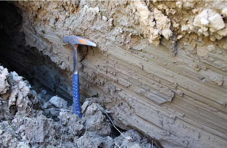
We observed markings that were scratched onto the fault plane. Like coarse sandpaper against wood, these scratches, or “slickenlines”, record movement as rock faces slipped past each other during the earthquake. Some of these markings were curved, and our method can tell us the direction the earthquake rupture was travelling.
Using computer models to simulate how the earthquake unfolded moment by moment, we were able to replicate the curved slickenlines observed in the field and relate them to rupture direction. This gave us the framework we needed to investigate rupture direction for past earthquakes on the Alpine Fault.
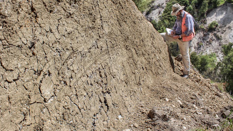
The Alpine Fault hasn’t had a major surface rupture since 1717. During field work, we visited three sites along the fault and examined natural outcrops, carefully exposing the fault plane using hand tools. We found 146 slickenlines, 30 of which were curved.
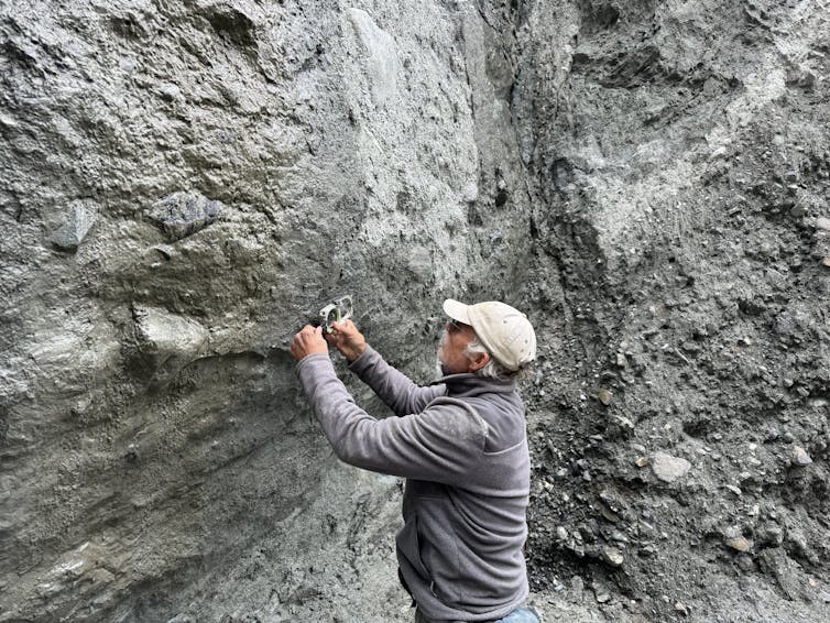
The curved geometry of slickenlines from the Alpine Fault’s most recent earthquake indicated it had travelled from the south towards the north. We also found evidence for rupturing in the opposite direction, suggesting that earthquakes can start both north and south.
On one outcrop, we found evidence of slickenlines from multiple earthquakes – a rare and tantalising find suggesting development of a longer history of rupture direction may be possible.
The technique we’ve applied is a novel, on-fault observational method for determining past rupture directions. Its full potential is yet to be tested, but already it’s applicable to faults worldwide.
Our research shows that the last Alpine Fault rupture was from the south, and that both directions are possible. New information about past earthquakes like this helps the scientific community produce realistic scenarios for the next major earthquake.
We now have direct evidence from the fault itself that we need to prepare for the scenario of very strong to severe shaking for the northern West Coast, Tasman, Marlborough and Canterbury regions in the next major Alpine Fault earthquake.![]()
*Jesse Kearse, Postdoctoral Researcher in Seismology, Kyoto University and Nicolas Barth, Assistant Professor of Geology, University of California, Riverside.
This article is republished from The Conversation under a Creative Commons license. Read the original article.
21 Comments
How are our hospital and medical facilities and staffings looking? Do we have fat in these systems to cope with the massive earthquakes that will one day hit some of our larger cities? Did we learn lessons from the pandemic? (There will be more)
obviously rhetorical questions
With all due respect to the people of ChCh, earthquakes of much greater severity could hit a number of urban centres.
The systems I work on, which were urgently overhauled and upgraded to meet pandemic needs, have already reverted to prioritizing short-term goals despite their stated commitment to be long-term pandemic-ready. They don’t directly touch health, but if another pandemic comes tomorrow, our pants are already 80% of the way back down to our ankles.
It would be good to have a full-scale hospital in Dunedin when this event occurred.
Exactly
And Wellington’s is inadequate
.. " if " this event occurred .... not " when " ... we do not know , cannot know , if it will ever occur ... " if ! " ...
So you think the tectonic plates might stop moving? If not, it WILL happen.
No, this is a case of when. The only way it doesn't happen is if a meteor wipes out the planet before the fault moves.
Did we learn lessons from the pandemic? (There will be more)
Have we created a robust quarantine facility other than using hotels in our largest city?
Will Queenstown lakes area remain insurable. Lots of monumental builds there so suspect much of the region can pay whatever.
Its the road network and road bridges on the northern West Coast that need consideration. these will allow (with repair) emergency services and evacuation activities.
Its impossible to build the required resilience into the more southern locations access roads with current budgets.
Its going to be a big thing, you probably need food and water for a month, a months worth of medicines etc if you are in areas mentioned, and genset and fuel etc.
latest cyclone showed Hawkes bay residents left to fend for themselves for weeks, it will be way worse with possibly thousands dead and major impacts to power and cities further north.
I expect my power to possibly be on off here in Auckland for weeks. Thus I have enough fuel to run genset for 6 hpours a day for 1 month on hand, I cycle the 30L tanks and use to fill vehicles so its constanly fresh, its a major consideration for me that I should run enough solar to run fridges and freezers most days
What we found through Gabrielle was that the further out we went the better prepared the farmers were physically, it was the mental side that was harder to support. We had more than a few "hard men" crying in front of us, and with us. We helped out where we could for a number of months, the most frustrating part of the whole crisis was the sheer number of urban folk who did nothing if they personally were ok. Drive through Havelock North 4 days after the cyclone and all you'd notice is a few trees damaged and a light pole on an angle, unless you went down Joll Road or Plassey Street and saw the piles of ruined belongings on the street and drying mud. Shout out to the folk who showed up to help those areas in the immediate aftermath.
Hastings was pretty much untouched, and a few places like churches and marae opened their doors to those who needed help but we very rarely came across anyone else who was actively out in places like Twyford offering supplies and support. It seemed like everyone assumed someone else would do something, and few took any action on their own initiative.
I'd say after a major quake the urban areas will be warzones (looting in and near urban areas was rife post-cyclone) while the rural folk will struggle with isolation more than physical needs.
We do the same as you for fuel, although ideally we'd store more, and we still need to get onto a solar setup and improve water storage.
I've heard they have pulled the pin on a lot of the infrastructure funding for Gabrielle and only doing a few bare essentials and leaving the rest as a patch up. Thought a journalists may of picked up on this.
Journalists have been MIA fo aa long time. It comes of peddling a lie (that economic growth is perpetually a: possible and b: desirable).
The problem is that we are passing the Limits to Growth, so things are getting harder to maintain; and balls already in the air ae competing, let alone new ones.
So the immediate takes precedence, anything longer gets shelved. In macro terms, that's what we voted for; short termism. We don't realise this, because?
Journalism is MIA.
There's a hole in my bucket, dear Liza....
Economic growth is not just exponentially possible , but is equally a desirable goal ...
... there are no limits to growth ! ..
There , you heard it here first . . . Wow !!! ... no limits to growth , how fantastic is that 😃
After the big one even urban people will be impacted, no power = freezers of food thrown out, perhaps no water for a bit, no hot water without gas....
I can see that mental health aspect on a greater scale due to the numbers impacted, some with no prep at all, how many NZers own a genset?
We do not have a standby emergency capability , how much help where the Navy in Hawkes bay, now multiply that to the entire West Coast. Gov of time would not send in the Army and there where few extra coppers. Bigger cities may have their own issues, WGTN could be badly hit in a south to north.
You may have to provide for your own security if necessary.
Who is paying for this research, I suspect insurance companies are pushing for information to model, to ensure they minimise their exposure.
... zigzackly correct .. there are vested interests pushing this doom & gloom scenario as if it is a 100 % iron clad certainty ...
Wakey wakey sheeples : You're being fleeced , once again by the spruikers of doom ...
Wakey wakey !
... It is a certainty. Whether it happens in your lifetime is the only question.
There's nothing to say that we can't have multiple "events" happening at the same time: for instance:
1. The Pacific techtonic plate catastrophically releases a snag formed as it subducts under the Australian-Indian plate.
Result: Tauranga,Papamoa, and surrounding areas are wiped off the face of the earth by the resulting earthquake and tsunami. It could include Napier and Hastings as well.
2. That giant volcano crater known as Lake Taupo blows its top:
Result: Being of the pyro-plastic type, this volcano produces so much ash that the whole of the Waikato farming land becomes permanently unsuitable for any kind of agriculture.
3. A new volcano rises out of the sea between Takapuna and Rangitoto. Remember Auckland's volcanic sub-structure is only dormant, not extinct.
Result: A devastating combination of tsunami, ash, earthquake, and red hot lava destroys the North Shore beaches and suburbs; the Auckland ports; and the Viaduct basin.
4 : funding for Shortland Street approved ...
RESULT : Kiwis remain braindeadily addicted to a moronic TV soap opera as if it's how we behave in real life ..
..." real life " , as in putting your cell phone down & observing the fuming beings around you ...
Sounds like a plug for " move to Aussie now".
We welcome your comments below. If you are not already registered, please register to comment
Remember we welcome robust, respectful and insightful debate. We don't welcome abusive or defamatory comments and will de-register those repeatedly making such comments. Our current comment policy is here.